Thursday, October 29, 2020

Acadia And Schoodic...And we didn't even bring bikes!

This post will start out with a big thank you to or friends who invited us to hang out, cook and play for a few days. One of our friends had a conference in the area which ended up turning virtual but they decided to keep the trip planned. Yay! 

I had a plan to do a pre-sunrise hike to a spot with less people than Cadillac Mountain. The trouble was, we had to find the right mountain.  I did my homework and at sunrise, 6:58AM,  the sun's angle would be at 104 degrees.  I found a spot near our house that would give us a view of the sunrise between the islands, perfecto!

It doesn't get any better than that.
 

Instead of getting up there in the dark and trying to figure out  what roads were closed due to COVID, where to park, what trail to take and if there were trees in the way we did a recon hike.  We actually encountered all of those things but found a clearing not far off the trail with some ledges that would be a great spot.  The trail we took was the Sluiceway trail to the Bernard Mountain Trail.  

This dog is not mine and not off-leash   (Photo by Warren E.)

The bottom is a little plain but the top is a magical ribbon of dirt through a thick moss covered forest floor.  Recon accomplished.

After our hike we took a side trip to smell the ocean air. 

When we got back we all took a drive to the top of Cadillac. I've been to the top of this mountain many times but rarely by car.  We didn't plan to stay until sunset because it gets so busy and even started driving away.  As we were passing the parking lot I said we should just turn in and look...

We were actually about 40 minutes early for the big event and it was getting chilly

But we stuck it out.

And it was worth it.

From here, the plan was to go home, eat, drink, be merry and then wake up at 5:00 to catch the next glimpse of the sun.  I wish all days could be that simple. 

O-Dark thirty (Photo by Warren E.)
Well, the getting up at 5:00 part came as a little shock to the system after the drinking and being merry part, but it was worth it too.

The moment before

If you have never done a hike in the night with lights, it is worth a try.  The woods are totally different at night.  Pro-tip, bring an extra light.   Because woods are really really dark if the one you have dies.

Hello Again
We got there in plenty of time to get in our spot and see the sun peak above the horizon.  As it turns out there was only a thin clearing at the horizon and then it turned to clouds.  This only made things more dramatic!

Spectacular!

Eme Approved (Photo by Warren E.)

 
OK!  Sun's up...Off to the next adventure!  We grabbed a quick shower and then it was off to Schoodic to meet my daughter for more hiking around.  

About as close to being swallowed up by the sea as I need.

We hiked from Schoodic point around the coast and out onto Little Moose Island. There she showed us a sea chasm that puts "Thunder Hole" to shame.
Attempt # 237 to get this shot with the wave. (Photo by Rose Edwards)

We ate lunch and played around the rocks a little longer before going on our hike.

Rose showed us a really big rock


And took our picture there (Photo by Rose Edwards)

We tried to put it back into place with no luck. (Photo by Rose Edwards)
From there it was off to hike to Shcoodic Head up the Anvil and back down Alder.  My daughter surprised me because the last I knew she kind of hated hiking.  Yet this was a pretty rugged trail.  It was a really great day of hiking that was capped off with some great food at Serendib.

The fall colors on the island were really amazing. (Photo by Rose Edwards)

As you can see, we didn't have time to miss having bikes.

Wednesday, September 9, 2020

The Dempsey Challenge 2020


Hear Ye Hear Ye, So we've got this little thing called COVID 19 happening right now.  Unfortunately that means that the actual Dempsey Challenge won't be happening this year.  And what that means is that we won't get to go get lobster and beer after we ride 100 miles.  BUMMER.  But, they are holding the event virtually.  And what that means is that you can still help support people going through cancer. 

Imagine, cancer by itself is a lonely disease.  Now imagine going through it now.  Bigger BUMMER.  The Dempsey Center helps people navigate what is likely the worst time in their life.  A quick statistic, Cancer still claims about 600,000 US lives/year and the COVID is currently "only" at 190,000.  Yeah, Cancer still sucks more. Not that it is a competition.

Kelly and I will still (probably, most likely) ride 100 miles on that day (maybe the next day if it is raining).  We actually signed up months ago, before we knew if it was happening or not because we have supported this cause for 10 years now.  The good news is that 100% of our registration fee gets donated to the Dempsey Center and doesn't go toward paying for our lobster and beer and all the other things it takes to run an event that size.  So there is a silver lining.

There are also no fundraising minimums this year. Because really, what could they do, say that you can not ride in the event that they are not hosting? That would just be silly. That means that it doesn't matter which one of us you donate through.  But I would say to donate to me! Because that way, maybe I'll raise enough to get the cycling shirt (like I really need it)

Donate to Brian's Page

But if you don't want Kelly to feel bad because you know she is quite competitive you still have the opportunity to

but hey, I write the blog so, there is that.  Either way the money all goes to the same place.  We will be riding it together.

But seriously

Donate to Brian's Page

I'd put some pictures in here but blogger is being a little bitch.  Maybe Later.


Note: If you donate on Thursday, September 10th your donation (may) get matched.  I’m honestly not sure how it works and maybe it is limited to $50 bucks but still, it is something.  So get to it!


Sunday, August 30, 2020

Baxter State Park

I haven't been to Baxter State Park since I was a kid.  And that is a long time ago.  This little thing called COVID-19 came through, maybe you have heard about it, and canceled the IronMan my wife was going to compete in.  No problem we would go and stay in the hotel we already booked in Canada for a vacation.  Nope, they closed their borders to us dirty Americans. can't really blame them.   Our third choice turned out to be a lot of fun.  We got an opportunity to rent a camp in Millinocket Maine instead.  OK, so Millinocket turns out to be the latest hyped COVID hot spot which made national news a few days before we got there. You can't escape this shit.  No big deal, we weren't planning on going anyplace more public than a 209,644 acre national park.  We're going to take our chances.  Enough on COVID.
The rock shows what the mountain would look like without fog.
We packed the car and embarked on the 3 hour drive to the camp.  Once we got there we took a quick ride on the Golden Road.  This road is a private dirt road where logging trucks travel 70MPH.  Luckly we didn't see one and decided that we would avoid it in the future.

Packed to the gills.
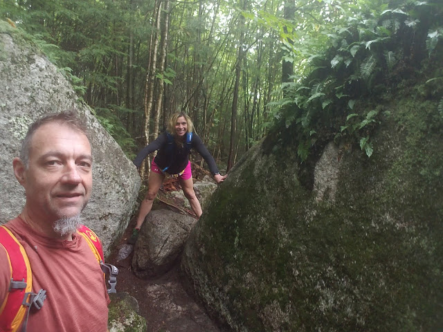
Our first trip brought us to the ice caves. The trail was almost as interesting as the caves themselves.  It was strewn with glacial erratic boulders.
Walking through 2 erratics.
There was still some ice at the bottom in late August.
A short side trail brings you to a view over several lakes.
The next big outing was a trip from the Baxter south gate to the South Branch Campground at the north end of the park on the Park Tote Road.  If you are into groading I would highly recommend it.  I planned a loop trip that would have been close to 130 miles but an out and back seemed more manageable.
I'm just going to post a bunch of random (kinda boring) road pictures
so that anybody considering this ride
can see what the surface looks like.
I like my Di2 bike.  I don't think it is a game changing technology like some but it generally works well.  Some people complain that they don't' need another thing to charge but I'm hear to tell you that you don't need to charge it that often.  So infrequent in fact that I didn't remember the last time I charged it.  I know it was before camping. I first thought of it after I had traveled 3-1/2 hours away from my charger with no known bike shop for 100 miles. Hmmm. How long does it take to go from flashing green to solid red?  Don't know.  Why do the red and green indicators come on simultaneously? Don't know.  So I was pretty conservative with my shifts, yeah, I tried not to shift at all in case I really needed to.
The reward at the halfway point.
So far we are up to about 10 hours in the north Maine woods and do we see any Moose? No. We saw a lot of great scenery but I was really hoping for a moose.
Ledge Falls was a nice place to stop for a snack but it was too cool to want to swim.
In all it was a great ride.  We were on cross bikes which were a great choice.  No need to go full mountain.  Of course a gravel bike (cross bike with tires that are 4mm wider) would be great.


It turns out that I probably could have shifted for another few hundred miles.  The green and red indicators together indicate that it is in "Manual Mode" Maybe it has been doing that since I updated the software a year ago.

4.4 miles to the peak, IDK, maybe it will take an hour. :)
Our next adventure brought us to the big rock pile itself. We chose Abol trail because it was the only parking reservation we could get.  GET YOUR PARKING RESERVATIONS EARLY.  After reading a lot of trail reports about how "serious" this trail was I packed way too much stuff.

The views are pretty good.
My wife has a pretty good case of acrophobia and we knew this hike might push her limits in places.  We also knew we weren't going over the Knife Edge on this trip.  But after the first wave of panic and thinking she would turn back, she did it! I'm proud of you honey!
If you click on this and zoom in you can see my wife trying to hide from the mountain.
For the first mile my wife was in "gazelle mode" and we did it in about 24 minutes. The next one in about 40 and the climby mile in about 1:10.

It really is just a big pile of rocks.
Maybe I am adding too many pictures, caption this.

Made it to the top in about 2.5 hours. 

The view is worth the climb.
That's all I've got to say about that.

Wednesday, August 5, 2020

Camping Groading

Our annual camping trip brought me to the land of dirt roads and hills. Well the first trip out didn't have any hills but it did have a few segments I was going to try for.  But my effort fell flat.
I had a 26 second lead until this happened.
Then the battery in my watch died.
I climbed a hill with no view.
Otherwise it was a great ride.  My second ride of the trip was somewhat unplanned.  I headed out to the north of the campground.  About 10 miles out I decided to ride 10 miles further to the top of Evens Notch.  I hadn't planned on a 40 mile ride, luckily the national parks have water at campgrounds.
Pump up your tires and pump up your water
I'd never climbed Evens from the south.  My goal wasn't so much a KOM but to make it to the top. My legs felt like stumps by the end of this ride and I'm not sure why.
Made it.
The last ride of the week was the big adventure.  It started with climbing Hurricane Mountain Road.  This beauty is a 2 mile climb with an average grade of 10% and a maximum grade of  27%.  It's a bitch.  It seemed steeper this time.  This wasn't the biggest hill of the climb but it was definitely the hardest.
That trail doesn't look that great.
I took a beautiful dirt road that follows a rolling river for about 5 miles up a mountain.  When I got to my planned cutoff to get back to camp it looked not all that trail like.  So I continued up the better trail option only to find out that it eventually turned into a rocky hiking trail. But on my way I did get to see a moose.

Excuse me sir, may I pass through your trail?
I eventually convinced him or her to move off to the side but it was definitely on the moose's schedule.
I also found a small patch of chanterelle mushrooms.
So back to the not so trail like trail I went.  Some parts were quite fine.  Some parts were swampy and buggy.  It was one of those trails where after a certain point you just give up trying to keep your feet dry and you are trudging through calf deep water.
But I made it to the other side. 
Since i was already wet and muddy and there are no shower facilities where we were camping I took advantage of a very refreshing (AKA cold) mountain stream. I'd kind of like to find this spot again.  Did I mention it was hot out? I stayed wet for about 10 minutes.
There was a nice pool that was deep enough to submerge in.

About 2 1/2 hours later than expected I was done.  10 miles/hour and 100' of climbing/mile.  I'm a tired puppy.
No Strava, I don't think I will be riding this route again.  Maybe pieces of it without the hike-a-bike.

Life is Good.